
The History of Navigation and Greenwich
 ⇐ Visiting Wonderful Greenwich.
Observation of the sun and stars were the beginning of navigation.
Without the benefits of having a North Star and Southern Cross, early navigation would have been very much delayed. As a result of this alone, all the benefits of trade and the distribution of knowledge would have been delayed.
The great and difficult steps, towards more advanced navigation were also essential to that development.
Right now we could still be without electricity, advanced medicine or even indoor plumbing.
Greenwich and the Greenwich Meridian have been central to the completion of the navigational puzzle.
.
.
.
.
.
Here is a brief history of that struggle, to navigate the world safely .
The North Star
It is always useful to know how to find the North Star (Polaris) or the Southern Cross (Crux)
This diagram shows part of the Great Bear (Ursa Major) constellation also known as the Panhandle. During the night this rotates around the sky but its lip always points towards Polaris.

The star itself is only of medium brightness but is quite alone in its position. It points so consistently close to due north that it can be reliably used for navigation.
It can be seen all over the Northern Hemisphere and, from some places, just south of the equator. More about the North Star.

The Southern Cross
The Southern Cross consists of four bright stars and also remains in a constant position in the sky. It can be seen all over the Southern Hemisphere and in some places north of the equator. More about the Southern Cross.
.
.
.
.
The Sun Compass
At noon when the sun is highest, it will be due South when seen from the Northern Hemisphere (or North if seen from the Southern Hemisphere). Its shadow points the other way. Without the advantage of a clock, direction cannot be found except at noon.
These days you can use a dial watch.
Rotate your watch so that the hour hand is pointing in the direction of the sun (keeping the watch flat). A line halfway between the hour hand and 12 o’clock is pointing due South (or North if in the Southern Hemisphere).
Why halfway ? It’s only a 12 hour watch. If its digital, then I’m sorry but you’re out of luck.
The ancients cleverly designed a simple combination of sun-dial (clock) and direction finder.
 Throughout one day the shadow of the sun is marked on the dial, which is kept in a fixed position.
During the following days, the compass is periodically rotated so that the sun’s shadow touches the nearest marked position. The noon mark, which is the shortest shadow mark, then points North (or South if in the Southern Hemisphere). By this method, direction can be found throughout the day.
As the days pass the height of the sun changes and the sun compass needs to be updated.
The Vikings, who were great travelers, used these sun compasses. The principle remains correct and a simple device can made quite easily. The wooden palette doesn’t even need to be round. A short plank of wood with a hole for a pencil shadow maker will do.
Latitude and Longitude
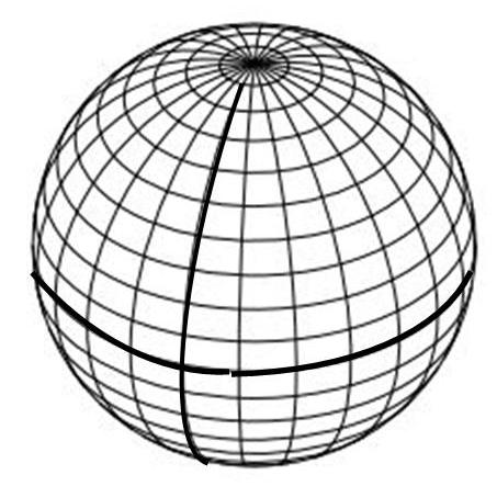 The lines of latitude are horizontal and are an equal distance from each other around the world. The thicker line is the equator at 0 degrees Latitude
The lines of Longitude are vertical and narrow towards the poles. The thicker line is the Prime Meridian at 0 degrees Longitude.
Knowing One’s Position North/South – Latitude
There is now some evidence to suggest that the Vikings used additional marks on their sun compasses to note the height of the sun, by its angle above the horizon.
Did the Vikings calculate latitude ?
Measuring the angle of the sun above the horizon, together with suitable tables of information for each day of the year, enables a navigator to determine position North or South of the Equator. That is, in angular degrees of Latitude.
Here is how two different positions would result in two different observations of the sun’s height above the horizon at noon.

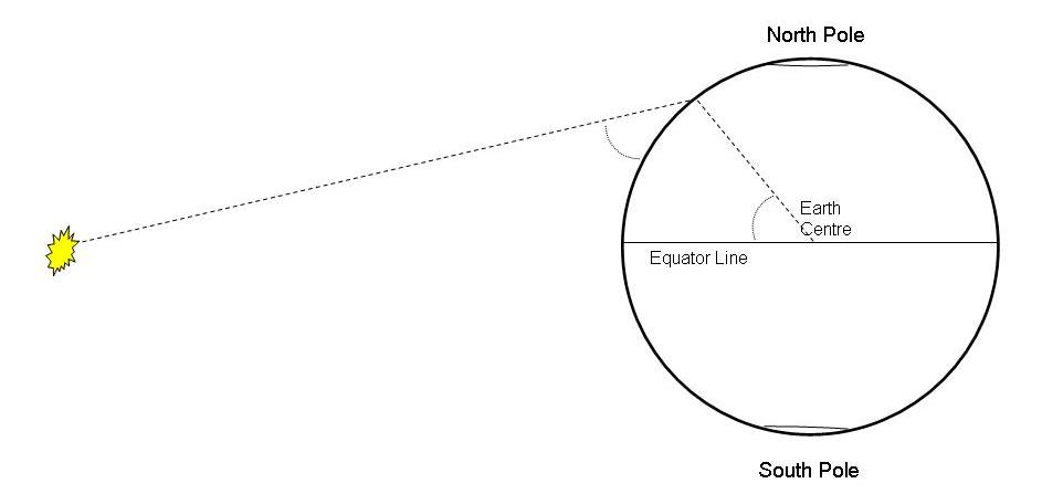
Latitude is therefore measured in degrees of angle. Either 0 to 90 degrees North of the equator or 0 to 90 degrees South of the equator.
If a navigator can determine Latitude then it is possible to cross an ocean to a known location. More importantly, the vessel can return to its original home Latitude.
In practice, because the earth is tilted upon its axis, numeric tables are required to compensate according to the time of year.
The sextant and magnetic compass were invented before the problem of finding Longitude (ones East/West position) was solved.
The Sextant
A sextant is a more accurate means of measuring the sun’s height above the horizon at noon (the sun’s angle of altitude) and therefore determining ones Latitude. It can also be used to navigate by the stars. More about sextants.
The Magnetic Compass
The magnetic compass is either a needle or a dial which points to the magnetic north pole.
Variation: The magnetic North Pole is not in the same position as the True North Pole. The difference is referred to as variation or declination and must be accounted for when plotting a course.
This variation changes slowly from year to year. However, due to fluctuations in the earths magnetic field, there can considerable difference in variation from place to place. Variation can be as much as 20 degrees either East or West of True North.
To avoid any confusion, compass angles are still referred to as either True or Magnetic.
Deviation: A compass will be affected by nearby metal. Even the old wooden ships had many iron nails and metal fittings. The iron ships had even more of a problem. This effect is termed deviation and is solved in one of three ways, either:-
Small vessels use a graph which shows the effect according to which way the vessel is pointing.
Larger vessels once used a Binnacle. This is a column upon which the compass stands and includes a number of corrective magnets.
In more recent decades, gyro compasses have been used and are described later.
The Problem of Longitude
Longitude is a position to east or west of a fixed line that runs from pole to pole. Such a line is referred to as a meridian.
Latitude by itself is not sufficient for the creation of accurate maps or sea charts. Without accurate charts, and a means to determine both ones Latitude and Longitude, a vessel is at extreme risk of striking reefs, underwater rocks and sandbanks. At night or in fog, a vessel is also at risk from any unseen land mass.
Right up until the 18th century the only method of determining a position East or West of ones starting point was by dead reckoning. That is, by measuring the distance traveled.
At sea, this was done by throwing a log over the side attached to a length of rope and measuring out how much rope was paid out over a fixed period of time. The rope had a number of knots at fixed intervals. These were counted out during the emptying of a sand glass.
The method was adjusted over time so that each knot that was pulled overboard indicated a speed of one nautical mile per hour. A nautical mile being equal to 1.151 land miles.
Speed at sea and in the air is still reckoned in knots (i.e. nautical miles per hour).
The information from this log speedometer was entered into a Log Book, which is still used today but contains more information. The term Log Book has been reused for Registration Books, Logging in to work and Logging into a computer.
If they had used a hollow float, we would now be Floating into work and Floating in to our computers. As daft as that may sound, it is no odder than referring to a Log of wood.
Navigation by dead reckoning eventually included vector diagrams that took into account the effect of tidal/current drift and sideways shift due to wind effect (leeway).
The inability to determine accurate Longitude came to a head when ships started to travel longer distances, resulting in many disasters with much loss of life, ships and cargoes.
Solving the Problem of Longitude
In 1567 Phillip II of Spain offered a substantial prize for a solution. The problem was so difficult that it took a further two hundred years to solve. The history of Longitude.
In 1714 the British Government offered a prize of £20,000 (~ £2M today). This eventually resulted in two proposed methods.
One was by observation of the moon’s position. This was very complicated, only of use when the moon was visible and impractical on the rolling decks of a ship.
The other method was by use of an accurate timepiece, which became known as a chronometer. John Harrison did succeed in producing a sufficiently accurate timepiece, and won the prize in 1773 after nearly 30 years of endeavour and just 3 years before his death.
The Board of Longitude, composed of scientists including Sir Isaac Newton, favoured the astronomical method and somewhat delayed giving the prize to a mere clock maker. Nevertheless, they did grant supportive monies along the way.
The Longitude Solution
First, it is necessary to establish a permanent starting point. That is, a fixed line that runs from pole to pole, designated as 0 degrees of Longitude and Prime Meridian.
All places on the earth, being a number of degrees either to the East or to the West of the Prime Meridian.
In practice the Greenwich Meridian (London) was established and is still used.
Then, the navigator’s chronometer must be set to noon, when noon occurs at that meridian. In practice, such timepieces are therefore set to Greenwich Mean Time (GMT).
From 1833 the observatory at Greenwich had a red time ball upon a mast. The time signal was given when the ball dropped. This was better than the usual noon day gun because sound takes time to travel. The Time Ball.
As one travels, sun sightings are taken each day at noon (the noon sight). The further West one travels, the later noon occurs compared with GMT shown by the chronometer.
At the moment of the noon sight, the altitude of the sun is measured to calculate Latitude and the time, on the Greenwich Mean Time chronometer, is used to calculate Longitude.
For example, if the chronometer, at local noon, shows Greenwich Mean Time to be 4 pm then the ship has traveled the same as 4 hours worth of earth’s rotation West of Greenwich. Thus:-

With the appropriate numeric tables and an accurate chronometer, a position can be calculated to less than a mile.
Whilst a degree of Latitude always represents a fixed distance (the lines are parallel), the lines of Longitude narrow towards the poles. Hence, for Longitude, numeric tables are required to turn degrees into nautical miles.
Longitude is measured as 0 to 180 degrees East of the Meridian or 0-180 degrees West of the Meridian. At exactly the opposite side of the world (180 degrees in either direction) is the International Dateline.
.
Understanding the International Dateline: Simple, A Bit More, Headache.
Each of 360 degrees of the earth’s sphere is divided into 60 minutes and each of those divided into 60 seconds.
On minute of Latitude is very nearly a nautical mile. Because lines of Longitude converge towards the poles, the equivalent distances have to be calculated.
Knowing Both Latitude and Longitude
By the late 18th century it was possible to pinpoint one’s position within a visible distance using only a sextant, a chronometer and the relevant tables of information. These days it is possible to do so within a quarter of mile, using the same method.
As a result of this advance it was possible to create accurate charts and safely navigate by them.
This method continued in use up until the age of electronics and has been essential to the development of the modern world.
The Rhumb Line and the Mercator Chart.
One nuisance of a problem had been solved earlier.
If one draws a line on a globe, from one port to another, and then unpeels the globe into a flat chart, the line will become curved. Therefore, to plot a course on such a chart, it is necessary plot it as a curve. This curve is known as a Rhumb line and a considerable nuisance because it must be calculated.
In 1569, before there were any accurate charts, Mercator invented a method of projecting the image of the earth’s globe onto a wall. The resulting charts distorted the land masses but allowed a straight line to be drawn as the shortest course between to places. Mercator projections are still used today.
Port and Starboard
The Vikings used a rudder on the right hand side of their longboats. This was known as the steering board side (Starboard). The left hand side was for the loading board (Larboard).
In 1845 the Secretary of the British Navy ordered the term Larboard side changed to Port side. Somewhere, it is noted that it was probably as result of British ship going aground due to confused communications. Larboard sounding too much like Starboard in a high wind.
Port side lights are Red (like Port wine) whilst Starboard lights are Green. The light, from these two colours, span from each side of the side of the vessel to the front. A small vessel’s rearward light is White.
Large vessels will use a more complicate array.
Modern Navigational Methods
The Gyro Compass: A spinning disk, within a device that allows it to “float”, will retain its orientation, just like a spinning top will stay upright. The application of electrical power will keep such a Gyro spinning. The axis can be set to point North and will continue to do so whilst the ship or aircraft turns around it.
In practice such devices need correction to counteract centrifugal effects. More about the Gyro Compass.
Radio Direction Finding: A simple system of locating two or more land beacons, using a directional receiver, and plotting their directions on a chart. Where the lines cross is one’s positions (referred to as triangulation).
The Decca System: This used a number of land based beacons. A small on-board electronic device then calculated one’s position. It could be as accurate as half a mile but only operated in some parts of the world.
The Global Positioning System: Relying on satellites in fixed orbits, this also uses time. The satellites transmit their position and very accurate time signals.
Using the time signals and the delay caused by distance, it is possible for the GPS unit to determine its distance from each satellite. As result it can calculate its position relative to those satellites.
Then, because the satellites are transmitting their position, the GPS unit can calculate its own position. As Sergai would say “sssimple”, or perhaps not. GPS Basics. More GPS.
Dedication
To all those who risked their lives and all those who tried to save them.
It’s a long way from sailing by the North Star to using GPS.


Thanks for the links back to EarthSky.org
LikeLike
November 22, 2013 at 16:01
Your Welcome 🙂
LikeLike
November 22, 2013 at 16:02
Whoa that’s a ton of into. Most useful to me in my explorations is ways of determining direction based on sun and stars. I’ve used the star trick for a while in night sky photography – you get great star trails focused around Polaris. Also, maybe one of these days I’ll remember Port and Starboard. For now, I’ll just content myself knowing there’s a reason for the terminology 🙂
LikeLike
November 25, 2013 at 01:02
Thank You. The seagoing and all it entails has been lifelong interest so the post was a labour of love. Nice to think that was of interest to even one other. 🙂
LikeLike
November 25, 2013 at 04:20
Way cool! Some extremely valid points! I appreciate you writing this write-up plus
the rest of the site is extremely good.
LikeLiked by 1 person
July 29, 2016 at 19:04